
County Clare topographic map
Interactive map
Click on the map to display elevation.
About this map
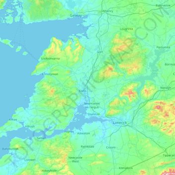
Name: County Clare topographic map, elevation, terrain.
Location: County Clare, Munster, Ireland (52.55447 -9.93876 53.16891 -8.28242)
Average elevation: 67 m
Minimum elevation: -4 m
Maximum elevation: 862 m
Other topographic maps
Click on a map to view its topography, its elevation and its terrain.
Haroldscross West
Haroldscross West, Terenure A ED, Dublin 6W, Dublin, County Dublin, Leinster, D6W F729, Ireland
Average elevation: 33 m
Maryborough
Maryborough, Portlaoise Rural ED, The Municipal District of Portlaoise, County Laois, Leinster, R32 KV20, Ireland
Average elevation: 96 m
North Bull Island
North Bull Island, Raheny St. Assam ED, Dublin 5, Dublin, County Dublin, Leinster, Ireland
Average elevation: 2 m
Beenkeragh
Beenkeragh, Kenmare Municipal District, County Kerry, Munster, Ireland
Average elevation: 656 m
Carrauntoohil
Carrauntoohil, Kenmare Municipal District, County Kerry, Munster, Ireland
Average elevation: 644 m
Wicklow Mountains National Park
Wicklow Mountains National Park, Mullaghcleevaun to Moanbane and Silsean, Glenbride, Lackan, The Municipal District of Baltinglass, County Wicklow, Leinster, Ireland
Average elevation: 324 m
Lugnaquilla
Lugnaquilla, The Municipal District of Baltinglass, County Wicklow, Leinster, Ireland
Average elevation: 697 m
Cherry Orchard
Cherry Orchard, Merchants Quay E ED, Dublin 8, Dublin, County Dublin, Leinster, Ireland
Average elevation: 25 m