
Gila County topographic map
Interactive map
Click on the map to display elevation.
About this map
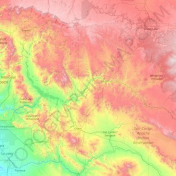
Name: Gila County topographic map, elevation, terrain.
Location: Gila County, Arizona, United States of America (32.98620 -111.72090 34.49911 -110.00031)
Average elevation: 1,362 m
Minimum elevation: 390 m
Maximum elevation: 2,422 m
Other topographic maps
Click on a map to view its topography, its elevation and its terrain.
Darling
United States of America > Arizona > Flagstaff
Darling, Flagstaff, Coconino County, Arizona, United States of America
Average elevation: 1,916 m
Maricopa County
United States of America > Arizona
Maricopa County, Arizona, United States of America
Average elevation: 549 m