
Hinnøya topographic map
Interactive map
Click on the map to display elevation.
About this map
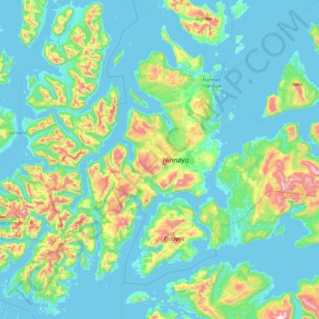
Name: Hinnøya topographic map, elevation, terrain.
Location: Hinnøya, Kvæfjord, Troms, Norway (68.29846 14.97793 68.97167 16.63356)
Average elevation: 176 m
Minimum elevation: -3 m
Maximum elevation: 1,278 m
Other topographic maps
Click on a map to view its topography, its elevation and its terrain.
Håkøya
Norway > Troms og Finnmark > Tromsø
Håkøya, Tromsø, Troms og Finnmark, 9104, Norway
Average elevation: 8 m
Vetle Skagastølstind
Vetle Skagastølstind, Luster, Sogn og Fjordane, Norway
Average elevation: 1,783 m
Gihtsejiegŋa
Gihtsejiegŋa, Nordkalottruta, Tysfjord, Nordland, Norway
Average elevation: 1,096 m
Jesus Lever-steinen
Jesus Lever-steinen, Løvstien, Solheims Boretslag, Solheim, Årstad, Gyldenpris, Bergen, Hordaland, 5057, Norway
Average elevation: 100 m