
Tso Moriri topographic map
Interactive map
Click on the map to display elevation.
About this map
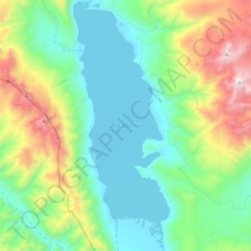
Name: Tso Moriri topographic map, elevation, terrain.
Location: Tso Moriri, Leh District, Jammu and Kashmir, India (32.76360 78.25919 33.01494 78.37442)
Average elevation: 5,044 m
Minimum elevation: 4,516 m
Maximum elevation: 6,657 m
Other topographic maps
Click on a map to view its topography, its elevation and its terrain.
Anantnag
India > Jammu and Kashmir > Anantnag
Anantnag, Jammu and Kashmir, India
Average elevation: 1,785 m
South Rimo Glacier
South Rimo Glacier, Leh District, Jammu and Kashmir, India
Average elevation: 5,595 m
Nun
Nun, Kargil District, Jammu and Kashmir, India
Average elevation: 5,988 m