
Avis topographic map
Interactive map
Click on the map to display elevation.
About this map
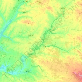
Name: Avis topographic map, elevation, terrain.
Location: Avis, Portalegre, Alto Alentejo, Alentejo, Portugal (38.94077 -8.15200 39.21862 -7.69667)
Average elevation: 171 m
Minimum elevation: 56 m
Maximum elevation: 389 m
Other topographic maps
Click on a map to view its topography, its elevation and its terrain.
Nossa Senhora da Graça do Divor
Portugal > Alentejo > Nossa Senhora da Graça do Divor
Nossa Senhora da Graça do Divor, Évora, Alentejo Central, Alentejo, Portugal
Average elevation: 309 m
Paul do Boquilobo Nature Reserve
Portugal > Alentejo > Azinhaga
Paul do Boquilobo Nature Reserve, Estrada dos Lazaros, Azinhaga, Golegã, Santarém, Lezíria do Tejo, Alentejo, 2140-999, Portugal
Average elevation: 27 m