
Vaud topographic map
Interactive map
Click on the map to display elevation.
About this map
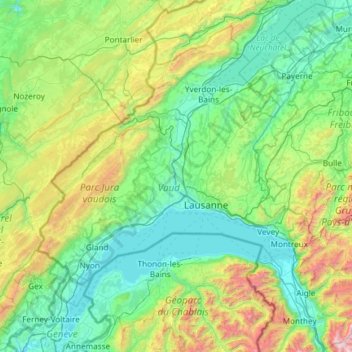
Name: Vaud topographic map, elevation, terrain.
Location: Vaud, Switzerland (46.18707 6.06386 46.98672 7.24919)
Average elevation: 840 m
Minimum elevation: 361 m
Maximum elevation: 2,938 m
Other topographic maps
Click on a map to view its topography, its elevation and its terrain.
Lonay
Switzerland > Vaud > Lonay
Lonay, District de Morges, Vaud, 1027, Switzerland
Average elevation: 429 m
L'Abbaye
Switzerland > Vaud > L'Abbaye
L'Abbaye, District du Jura-Nord vaudois, Vaud, Switzerland
Average elevation: 1,171 m
Solalex
Switzerland > Vaud > Solalex
Solalex, District d'Aigle, Vaud, Switzerland
Average elevation: 1,851 m
Montreux
Switzerland > Vaud > Montreux
Montreux, District de la Riviera-Pays-d’Enhaut, Vaud, Switzerland
Average elevation: 820 m
Aigle
Switzerland > Vaud > Aigle
Aigle, District d'Aigle, Vaud, 1860, Switzerland
Average elevation: 647 m
Nyon
Switzerland > Vaud > Nyon
Nyon, District de Nyon, Vaud, 1260, Switzerland
Average elevation: 404 m