
New York topographic map
Interactive map
Click on the map to display elevation.
About this map
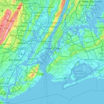
Name: New York topographic map, elevation, terrain.
Location: New York, United States (40.47658 -74.25884 40.91763 -73.70023)
Average elevation: 19 m
Minimum elevation: -6 m
Maximum elevation: 207 m
The city's land has been altered substantially by human intervention, with considerable land reclamation along the waterfronts since Dutch colonial times; reclamation is most prominent in Lower Manhattan, with developments such as Battery Park City in the 1970s and 1980s. Some of the natural relief in topography has been evened out, especially in Manhattan.
Other topographic maps
Click on a map to view its topography, its elevation and its terrain.
Town of Angelica
United States > New York > Allegany County
Town of Angelica, Allegany County, New York, 14709, United States
Average elevation: 517 m
Village of Kings Point
United States > New York > Nassau County
Village of Kings Point, Town of North Hempstead, Nassau County, New York, 11024, United States
Average elevation: 9 m
Appleton
United States > New York > Niagara County > Town of Newfane
Appleton, Town of Newfane, Niagara County, New York, 14008, United States
Average elevation: 98 m
Burt
United States > New York > Niagara County > Town of Newfane
Burt, Town of Newfane, Niagara County, New York, 14028, United States
Average elevation: 96 m
Town of Newfane
United States > New York > Niagara County
Town of Newfane, Niagara County, New York, United States
Average elevation: 101 m
Nashville
United States > New York > Nashville
Nashville, Wheatfield Town, Niagara County, New York, 14120, United States
Average elevation: 178 m
Parish
United States > New York > Parish
Parish, Town of Parish, Oswego County, New York, 13131, United States
Average elevation: 147 m
Centenary
United States > New York > Centenary
Centenary, Town of Clarkstown, Rockland County, New York, 10927, United States
Average elevation: 55 m