
Flemish Brabant topographic map
Interactive map
Click on the map to display elevation.
About this map
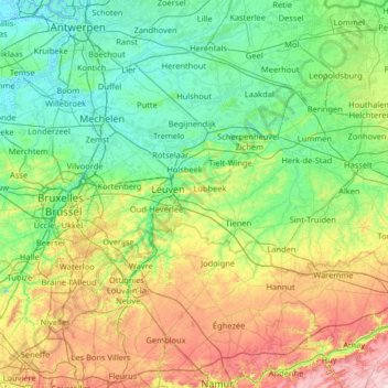
Name: Flemish Brabant topographic map, elevation, terrain.
Location: Flemish Brabant, Flanders, Belgium (50.68738 3.88932 51.04982 5.18803)
Average elevation: 71 m
Minimum elevation: -3 m
Maximum elevation: 303 m
Other topographic maps
Click on a map to view its topography, its elevation and its terrain.
Oostduinkerke
Belgium > Flanders > Groenendijk
Oostduinkerke, Groenendijk, Veurne, West Flanders, Flanders, 8620, Belgium
Average elevation: 3 m
Maasmechelen
Belgium > Flanders > Maasmechelen
Maasmechelen, Tongeren, Limburg, Flanders, Belgium
Average elevation: 57 m