
Lake County topographic map
Interactive map
Click on the map to display elevation.
About this map
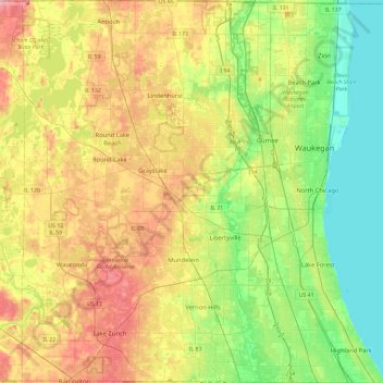
Name: Lake County topographic map, elevation, terrain.
Location: Lake County, Illinois, United States (42.15231 -88.19954 42.49563 -87.74949)
Average elevation: 222 m
Minimum elevation: 173 m
Maximum elevation: 293 m
Other topographic maps
Click on a map to view its topography, its elevation and its terrain.
Olney
United States > Illinois > Richland County
Olney, Richland County, Illinois, 62450, United States
Average elevation: 143 m