
Bjelašnica topographic map
Interactive map
Click on the map to display elevation.
About this map
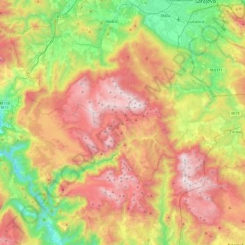
Name: Bjelašnica topographic map, elevation, terrain.
Location: Bjelašnica, Trnovo municipality, Sarajevo Canton, B&H (43.54561 17.96615 43.81930 18.45061)
Average elevation: 1,094 m
Minimum elevation: 286 m
Maximum elevation: 2,062 m
Other topographic maps
Click on a map to view its topography, its elevation and its terrain.
Galičica
B&H > Entity Federation of Bosnia and Herzegovina > Galičica
Galičica, Gornji Vakuf/Uskoplje municipality, Central Bosnia Canton, Entity Federation of Bosnia and Herzegovina, 70240, B&H
Average elevation: 796 m
Herzegovina-Neretva Canton
B&H > Federation of Bosnia and Herzegovina
Herzegovina-Neretva Canton, Federation of Bosnia and Herzegovina, B&H
Average elevation: 672 m
Župica
B&H > Entity Federation of Bosnia and Herzegovina > Župica
Župica, Drvar municipality, Canton 10, Entity Federation of Bosnia and Herzegovina, B&H
Average elevation: 676 m
Glavatičevo
Glavatičevo, Konjic municipality, Herzegovina-Neretva Canton, B&H
Average elevation: 594 m
Čvrsnica
B&H > Entity Federation of Bosnia and Herzegovina > Turističko naselje Risovac
Čvrsnica, Put munike, Zelenike, Naselje Risovac, Turističko naselje Risovac, Jablanica municipality, Herzegovina-Neretva Canton, Entity Federation of Bosnia and Herzegovina, B&H
Average elevation: 1,359 m
Central Bosnia Canton
B&H > Federation of Bosnia and Herzegovina
Central Bosnia Canton, Federation of Bosnia and Herzegovina, B&H
Average elevation: 940 m