
Grand County topographic map
Interactive map
Click on the map to display elevation.
About this map
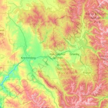
Name: Grand County topographic map, elevation, terrain.
Location: Grand County, Colorado, United States of America (39.68408 -106.65283 40.48625 -105.62609)
Average elevation: 2,899 m
Minimum elevation: 2,081 m
Maximum elevation: 4,281 m
Other topographic maps
Click on a map to view its topography, its elevation and its terrain.
Redcliff
United States of America > Colorado
Redcliff, Hinsdale County, Colorado, United States of America
Average elevation: 3,710 m
Crested Butte
United States of America > Colorado > Crested Butte
Crested Butte, Gunnison County, Colorado, 81224, United States of America
Average elevation: 2,798 m
Park County
United States of America > Colorado
Park County, Colorado, United States of America
Average elevation: 2,937 m