
Panaji topographic map
Interactive map
Click on the map to display elevation.
About this map
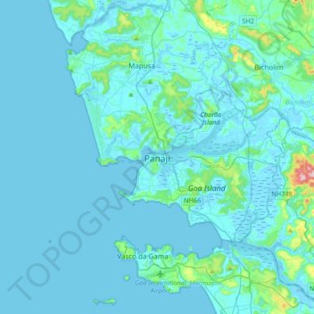
Name: Panaji topographic map, elevation, terrain.
Location: Panaji, Tiswadi, North Goa, Goa, 403100, India (15.33899 73.66821 15.65899 73.98821)
Average elevation: 19 m
Minimum elevation: -3 m
Maximum elevation: 285 m
Panjim was annexed by India with the rest of Goa and the former Portuguese territories after the Indian invasion of Portuguese India in 1961. It became a state-capital on Goa's elevation to statehood in 1987. Between 1961 and 1987, it was the capital of the Union Territory of Goa, Daman and Diu. A new Legislative Assembly complex was inaugurated in March 2000, across the Mandovi River, in Alto Porvorim. Panjim is also the administrative headquarters of North Goa district.