
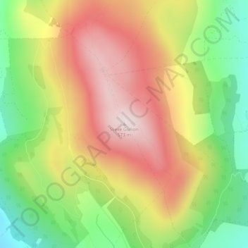
Slieve Gullion topographic map
Interactive map
Click on the map to display elevation.
About this map
Name: Slieve Gullion topographic map, elevation, terrain.
Average elevation: 330 m
Minimum elevation: 86 m
Maximum elevation: 569 m
Other topographic maps
Click on a map to view its topography, its elevation and its terrain.
Moneyneany
United Kingdom > Northern Ireland > County Londonderry
Moneyneany, County Londonderry, Ulster, Northern Ireland, BT45 7DZ, United Kingdom
Average elevation: 262 m
Northern Ireland
United Kingdom > Northern Ireland
Northern Ireland, United Kingdom
Average elevation: 83 m
Slieve Donard
United Kingdom > Northern Ireland
Slieve Donard, County Down, Northern Ireland, BT33 0HD, United Kingdom
Average elevation: 503 m
Lisdrumgullion
United Kingdom > Northern Ireland > Newry
Lisdrumgullion, Newry, County Down, Northern Ireland, BT35 6BH, United Kingdom
Average elevation: 41 m
Mourne Mountains West
United Kingdom > Northern Ireland
Mourne Mountains West, County Down, Northern Ireland, United Kingdom
Average elevation: 272 m