
Dinagat Islands topographic map
Interactive map
Click on the map to display elevation.
About this map
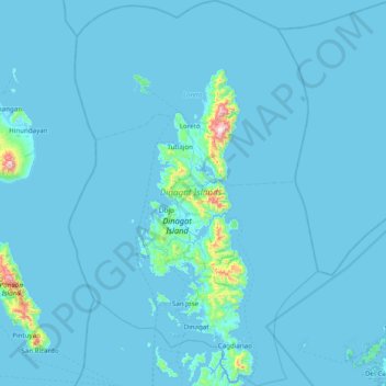
Name: Dinagat Islands topographic map, elevation, terrain.
Location: Dinagat Islands, Caraga, Philippines (9.84337 125.33415 10.60837 125.83670)
Average elevation: 24 m
Minimum elevation: -1 m
Maximum elevation: 911 m
Dinagat Islands is a young island-province at the northern tip of Mindanao. Many describe Dinagat Islands as a hidden gem of the Caraga Region XIII. The Islands are enriched with great bio-diversity, abundant natural wonders and rich resources. Dinagat Islands has a multitude of fascinating white sandy beaches with arrays of colossal rock formations. These sites and attractions are as diverse as the topography of the islands and islets.