
Ipoh topographic map
Interactive map
Click on the map to display elevation.
About this map
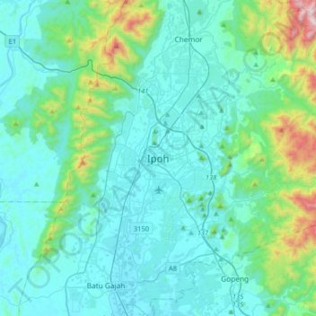
Name: Ipoh topographic map, elevation, terrain.
Location: Ipoh, Kinta, Perak, 30450, Malaysia (4.43868 100.93002 4.75868 101.25002)
Average elevation: 205 m
Minimum elevation: 15 m
Maximum elevation: 1,364 m
Other topographic maps
Click on a map to view its topography, its elevation and its terrain.
Gunung Keledang
Gunung Keledang, Ipoh, Kinta, Perak, Malaysia
Average elevation: 450 m