
Shandong topographic map
Interactive map
Click on the map to display elevation.
About this map
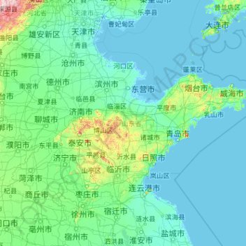
Name: Shandong topographic map, elevation, terrain.
Location: Shandong, China (34.37858 114.81691 38.52183 122.95676)
Average elevation: 39 m
Minimum elevation: -3 m
Maximum elevation: 1,957 m
Geographically, the southern hills average an elevation of 200 meters (660 ft), while the coastal areas remain relatively flat. Most of the soil is loose, well-ventilated, and rich in minerals and organic matter that enable full development of the root systems.