
Bisbee topographic map
Interactive map
Click on the map to display elevation.
About this map
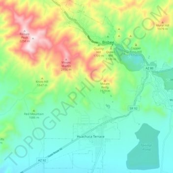
Name: Bisbee topographic map, elevation, terrain.
Location: Bisbee, Cochise County, Arizona, United States (31.37749 -109.95331 31.46222 -109.86746)
Average elevation: 1,676 m
Minimum elevation: 1,436 m
Maximum elevation: 2,238 m
Natural vegetation around Bisbee has a semi-desert appearance with shrubby acacia, oak and the like, along with cacti, grass, ocotillo and yucca. The town itself is much more luxuriant with native trees such as cypress, sycamore and cottonwood plus the introduced ailanthus and Old World cypresses, cedars and pines. Palms are capable of large size, but are not reliably hardy. A few higher-elevation trees such as blue spruce and white fir are growing fairly well in Bisbee.