
Møre og Romsdal topographic map
Interactive map
Click on the map to display elevation.
About this map
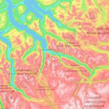
Name: Møre og Romsdal topographic map, elevation, terrain.
Location: Sunndal, Møre og Romsdal, Norway (62.35319 8.20613 62.94126 9.24382)
Average elevation: 868 m
Minimum elevation: 0 m
Maximum elevation: 1,986 m
Other topographic maps
Click on a map to view its topography, its elevation and its terrain.
Håkøya
Norway > Troms og Finnmark > Tromsø
Håkøya, Tromsø, Troms og Finnmark, 9104, Norway
Average elevation: 8 m
Vetle Skagastølstind
Vetle Skagastølstind, Luster, Sogn og Fjordane, Norway
Average elevation: 1,783 m
Gihtsejiegŋa
Gihtsejiegŋa, Nordkalottruta, Tysfjord, Nordland, Norway
Average elevation: 1,096 m