
Philadelphia County topographic map
Interactive map
Click on the map to display elevation.
About this map
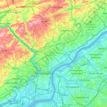
Name: Philadelphia County topographic map, elevation, terrain.
Location: Philadelphia County, Pennsylvania, United States of America (39.86701 -75.28030 40.13796 -74.95583)
Average elevation: 39 m
Minimum elevation: -4 m
Maximum elevation: 139 m
Other topographic maps
Click on a map to view its topography, its elevation and its terrain.
West Nicholson
United States of America > Pennsylvania > West Nicholson
West Nicholson, Wyoming County, Pennsylvania, United States of America
Average elevation: 350 m
Roulette Township
United States of America > Pennsylvania > Roulette Township
Roulette Township, Potter County, Pennsylvania, 16746, United States of America
Average elevation: 587 m
Delaware County
United States of America > Pennsylvania
Delaware County, Pennsylvania, United States of America
Average elevation: 76 m