
Aosta Valley topographic map
Interactive map
Click on the map to display elevation.
About this map
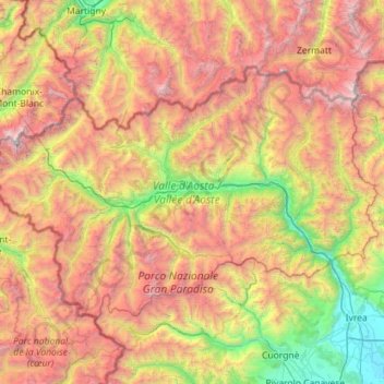
Name: Aosta Valley topographic map, elevation, terrain.
Location: Aosta Valley, Italy (45.46695 6.80245 45.98768 7.93950)
Average elevation: 2,080 m
Minimum elevation: 214 m
Maximum elevation: 4,787 m
Other topographic maps
Click on a map to view its topography, its elevation and its terrain.
Pussey
Italy > Aosta Valley > Courmayeur
Pussey, Courmayeur, Aosta Valley, 11013, Italy
Average elevation: 1,561 m
Larzey
Italy > Aosta Valley > Courmayeur > Larzey
Larzey, Courmayeur, Aosta Valley, 11013, Italy
Average elevation: 1,596 m
Courmayeur
Italy > Aosta Valley > Courmayeur
Courmayeur, Aosta Valley, 11013, Italy
Average elevation: 2,367 m
Valtournenche
Italy > Aosta Valley > Valtournenche
Valtournenche, Aosta Valley, Italy
Average elevation: 2,640 m
Gran Paradiso
Italy > Aosta Valley > Valsavarenche
Gran Paradiso, Valsavarenche, Aosta Valley, Italy
Average elevation: 3,459 m
Ghiacciaio del Miage
Italy > Aosta Valley > Courmayeur
Ghiacciaio del Miage, Sentiero 15 Rifugio Gonella, Courmayeur, Aosta Valley, Italy
Average elevation: 2,911 m