Geolocate

Jalandhar topographic map

Interactive map

Click on the map to display elevation.

About this map

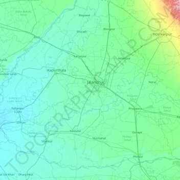
Name: Jalandhar topographic map, elevation, terrain.

Location: Jalandhar, Punjab, India (30.97450 75.06624 31.61940 75.94889)

Average elevation: 241 m

Minimum elevation: 211 m

Maximum elevation: 516 m

Other topographic maps

Click on a map to view its topography, its elevation and its terrain.

Talwan

India > Punjab > Talwan

Talwan, Jullundur, Jalandhar, Punjab, India

Average elevation: 236 m

Gurdaspur

India > Punjab

Gurdaspur, Punjab, India

Average elevation: 461 m

Sutlej River

India > Punjab

Sutlej River, Ludhiana, Punjab, 172026, India

Average elevation: 1,539 m

Jalandhar

India > Punjab > Jalandhar

Jalandhar, Jalandhar I Tahsil, Jalandhar, Punjab, 144001, India

Average elevation: 237 m