
Maun topographic map
Interactive map
Click on the map to display elevation.
About this map
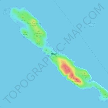
Name: Maun topographic map, elevation, terrain.
Location: Maun, Town of Pag, Zadar County, Croatia (44.40062 14.88093 44.45623 14.96905)
Average elevation: 3 m
Minimum elevation: -3 m
Maximum elevation: 61 m
Other topographic maps
Click on a map to view its topography, its elevation and its terrain.
Zagreb
Zagreb (/ˈzɑːɡrɛb, ˈzæɡrɛb, zɑːˈɡrɛb/ ZAH-greb, ZAG-reb, zah-GREB; Croatian pronunciation: (listen)) is the capital and largest city of Croatia. It is in the northwest of the country, along the Sava river, at the southern slopes of the Medvednica mountain. Zagreb lies at an elevation of…
Average elevation: 193 m