
Chatham Islands topographic map
Interactive map
Click on the map to display elevation.
About this map
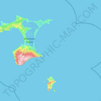
Name: Chatham Islands topographic map, elevation, terrain.
Location: Chatham Islands, 8942, New Zealand (-44.43499 -176.92987 -43.56263 -175.83119)
Average elevation: 7 m
Minimum elevation: 0 m
Maximum elevation: 288 m
Other topographic maps
Click on a map to view its topography, its elevation and its terrain.
Mataka
New Zealand > Northland > Far North District > Bay of Islands-Whangaroa Community
Average elevation: 45 m