
Far-North topographic map
Interactive map
Click on the map to display elevation.
About this map
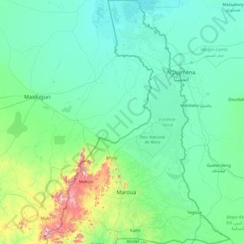
Name: Far-North topographic map, elevation, terrain.
Location: Far-North, Cameroon (9.93348 13.41220 13.08333 15.68910)
Average elevation: 357 m
Minimum elevation: 278 m
Maximum elevation: 1,312 m
These rivers all follow a tropical regime, fluctuating between high water in the wet season (May to September) and low water in the dry season (October to April). At the height of the dry season, many of the waterways disappear completely or else diminish to a mere trickle. The Logone all but disappears during the wet season. The low elevation of the Chad basin (200–500 metres) causes flooding during the wet season; the Logone is especially prone to this, and much of its basin is marshlike conditions along its length during the wet season. Even during the dry season, some of these remain, called Yaéré in Fulfulde. The El Beïd and Serbewel Rivers drain these marshy areas into Lake Chad. The Diamaré Plain, part of the Chad plain, occupies the southeastern third of the province. It is not as prone to flooding due to a number of inselbergs through the area.
Other topographic maps
Click on a map to view its topography, its elevation and its terrain.
Alantika Mountains
Alantika Mountains, Béka, Faro, North, Cameroon
Average elevation: 1,618 m
Mandara Mountains
Mandara Mountains, Koza, Mayo-Tsanaga, Far-North, Cameroon
Average elevation: 868 m
Lake Bambili
Lake Bambili, Banja-Bambili-Babanki, Tubah, CUB, Mezam, Northwest, Cameroon
Average elevation: 2,295 m
Bamendjing
Cameroon > West > Bamendjing
Bamendjing, Bamboutos, West, Cameroon
Average elevation: 1,168 m
Mount Cameroon
Mount Cameroon, Meme, Southwest, Cameroon
Average elevation: 3,645 m