
Middlesex County topographic map
Interactive map
Click on the map to display elevation.
About this map
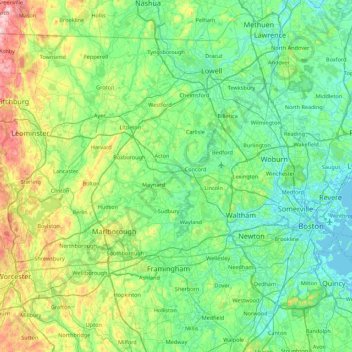
Name: Middlesex County topographic map, elevation, terrain.
Location: Middlesex County, Massachusetts, USA (42.15674 -71.89877 42.73659 -71.01978)
Average elevation: 80 m
Minimum elevation: -4 m
Maximum elevation: 391 m
Other topographic maps
Click on a map to view its topography, its elevation and its terrain.
Mount Owen
USA > Massachusetts > Ashfield
Mount Owen, Ashfield, Franklin, Massachusetts, 01330, USA
Average elevation: 298 m
Chester
USA > Massachusetts > Chester
Chester, Berkshire, Massachusetts, 01011, USA
Average elevation: 370 m
Baldy Mountain
USA > Massachusetts > Tyringham
Baldy Mountain, Tyringham, Berkshire, Massachusetts, 01264, USA
Average elevation: 497 m
Goat Rocks
USA > Massachusetts > West Tisbury
Goat Rocks, West Tisbury, Dukes County, Massachusetts, 02575, USA
Average elevation: 30 m
Hubbard Brook
USA > Massachusetts > Sheffield
Hubbard Brook, Sheffield, Berkshire, Massachusetts, 01257, USA
Average elevation: 215 m