
Porto topographic map
Interactive map
Click on the map to display elevation.
About this map
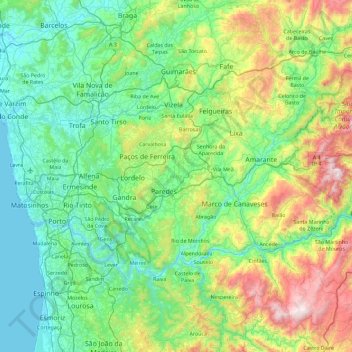
Name: Porto topographic map, elevation, terrain.
Location: Porto, Tâmega e Sousa, North, Portugal (41.00138 -8.78906 41.47197 -7.87558)
Average elevation: 314 m
Minimum elevation: -2 m
Maximum elevation: 1,392 m
Other topographic maps
Click on a map to view its topography, its elevation and its terrain.
Oliveira do Douro
Portugal > North > Oliveira do Douro
Oliveira do Douro, Vila Nova de Gaia, Porto, Área Metropolitana do Porto, North, Portugal
Average elevation: 80 m