
Lower Bavaria topographic map
Interactive map
Click on the map to display elevation.
About this map
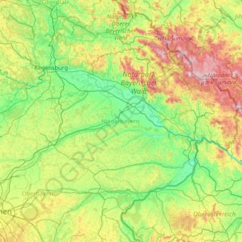
Name: Lower Bavaria topographic map, elevation, terrain.
Location: Lower Bavaria, Bavaria, Germany (48.20666 11.59486 49.17362 13.83964)
Average elevation: 505 m
Minimum elevation: 279 m
Maximum elevation: 1,411 m
Other topographic maps
Click on a map to view its topography, its elevation and its terrain.