
Harare Province topographic map
Interactive map
Click on the map to display elevation.
About this map
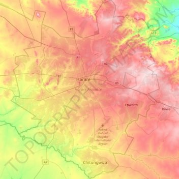
Name: Harare Province topographic map, elevation, terrain.
Location: Harare Province, Zimbabwe (-18.05099 30.87743 -17.65716 31.22145)
Average elevation: 1,461 m
Minimum elevation: 1,281 m
Maximum elevation: 1,603 m
Harare (/həˈrɑːreɪ/; officially Salisbury until 1982) is the capital and most populous city of Zimbabwe. The city proper has an area of 960.6 km2 (371 mi2) and an estimated population of 1,606,000 in 2009, with 2,800,000 in its metropolitan area in 2006. Situated in north-eastern Zimbabwe in the country's Mashonaland region, Harare is a metropolitan province, which also incorporates the municipalities of Chitungwiza and Epworth. The city sits on a plateau at an elevation of 1,483 metres (4,865 feet) above sea level and its climate falls into the subtropical highland category.
Other topographic maps
Click on a map to view its topography, its elevation and its terrain.
Mukuvisi Woodlands
Zimbabwe > Harare Province > Harare
Mukuvisi Woodlands, Glenara Avenue South, Cranborne, Harare, Harare Province, 00234, Zimbabwe
Average elevation: 1,496 m
Ward 4
Zimbabwe > Harare Province > Epworth
Ward 4, Epworth, Harare Province, Zimbabwe
Average elevation: 1,480 m
Chitungwiza
Zimbabwe > Harare Province > Chitungwiza
Chitungwiza, Harare Province, 0263, Zimbabwe
Average elevation: 1,438 m