
Idukki topographic map
Interactive map
Click on the map to display elevation.
About this map
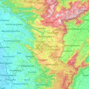
Name: Idukki topographic map, elevation, terrain.
Location: Idukki, Kerala, India (9.27253 76.61805 10.35783 77.41194)
Average elevation: 599 m
Minimum elevation: -3 m
Maximum elevation: 2,644 m
Other topographic maps
Click on a map to view its topography, its elevation and its terrain.
Chengannur
India > Kerala > Chengannur > Chengannur
Chengannur, Alappuzha, Kerala, 689121, India
Average elevation: 13 m
Meesapulimala
Meesapulimala, Idukki, Kerala, 685618, India
Average elevation: 2,221 m