
Iowa topographic map
Interactive map
Click on the map to display elevation.
About this map
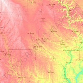
Name: Iowa topographic map, elevation, terrain.
Location: Iowa, United States (40.37560 -96.63972 43.50116 -90.14006)
Average elevation: 316 m
Minimum elevation: 129 m
Maximum elevation: 602 m
Iowa is generally not flat; most of the state consists of rolling hills. Iowa can be divided into eight landforms based on glaciation, soils, topography, and river drainage. Loess hills lie along the western border of the state, some of which are several hundred feet thick. Northeast Iowa along the Upper Mississippi River is part of the Driftless Area, consisting of steep hills and valleys which appear almost mountainous.
Other topographic maps
Click on a map to view its topography, its elevation and its terrain.
Russell
United States > Iowa > Lucas County
Russell, Lucas County, Iowa, United States
Average elevation: 311 m
Woodbury County
United States > Iowa > Woodbury County
Woodbury County, Iowa, United States
Average elevation: 376 m