
Nun topographic map
Interactive map
Click on the map to display elevation.
About this map
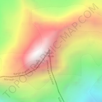
Name: Nun topographic map, elevation, terrain.
Location: Nun, Kargil District, Jammu and Kashmir, India (33.98183 76.02492 33.98193 76.02502)
Average elevation: 5,988 m
Minimum elevation: 4,840 m
Maximum elevation: 7,057 m
Other topographic maps
Click on a map to view its topography, its elevation and its terrain.
Anantnag
India > Jammu and Kashmir > Anantnag
Anantnag, Jammu and Kashmir, India
Average elevation: 1,785 m
Tso Moriri
Tso Moriri, Leh District, Jammu and Kashmir, India
Average elevation: 5,044 m
South Rimo Glacier
South Rimo Glacier, Leh District, Jammu and Kashmir, India
Average elevation: 5,595 m