
Guadalupe Peak topographic map
Interactive map
Click on the map to display elevation.
About this map
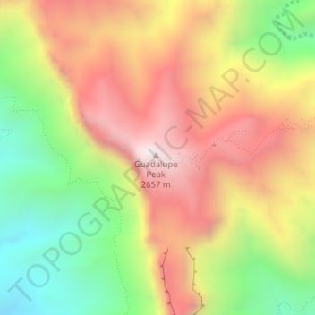
Name: Guadalupe Peak topographic map, elevation, terrain.
Location: Guadalupe Peak, Culberson County, Texas, 79847, USA (31.89118 -104.86055 31.89128 -104.86045)
Average elevation: 2,151 m
Minimum elevation: 1,625 m
Maximum elevation: 2,651 m
Other topographic maps
Click on a map to view its topography, its elevation and its terrain.
La Villita
USA > Texas > San Antonio
La Villita, San Antonio, Bexar County, Texas, USA
Average elevation: 202 m
Post Oak Ridge
USA > Texas > Lago Vista
Post Oak Ridge, Lago Vista, Travis County, Texas, 78645, USA
Average elevation: 314 m
Denny Mountain
Denny Mountain, Nacogdoches County, Texas, 75760, USA
Average elevation: 137 m
Big Bend National Park
USA > Texas > Panther Junction
Big Bend National Park, Main Park Road, Panther Junction, Brewster County, Texas, 79834, USA
Average elevation: 934 m