
Dang topographic map
Interactive map
Click on the map to display elevation.
About this map
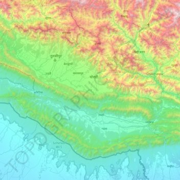
Name: Dang topographic map, elevation, terrain.
Location: Dang, Rapti, Mid-Western Development Region, Nepal (27.67644 82.00754 28.25943 82.81032)
Average elevation: 712 m
Minimum elevation: 113 m
Maximum elevation: 2,674 m
Other topographic maps
Click on a map to view its topography, its elevation and its terrain.
Thuli Bheri
Nepal > Mid-Western Development Region > Tripurakot
Thuli Bheri, Tripurakot, Dolpa, Karnali, Mid-Western Development Region, Nepal
Average elevation: 2,300 m
Ghaghara River
Nepal > Mid-Western Development Region
Ghaghara River, Dailekh, Bheri, Mid-Western Development Region, 271833, Nepal
Average elevation: 1,522 m