Geolocate

Bomerano topographic map

Interactive map

Click on the map to display elevation.

About this map

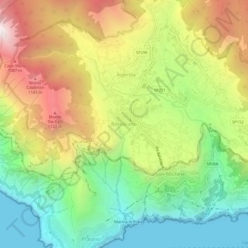
Name: Bomerano topographic map, elevation, terrain.

Location: Bomerano, Agerola, Naples, Campania, 80051, Italy (40.60970 14.51836 40.64970 14.55836)

Average elevation: 579 m

Minimum elevation: -1 m

Maximum elevation: 1,357 m

Other topographic maps

Click on a map to view its topography, its elevation and its terrain.

Naples

Italy > Campania > Naples

In 1755, the Duke of Noja commissioned an accurate topographic map of Naples, later known as the Map of the Duke of Nojo, employing rigorous surveying accuracy and becoming an essential urban planning tool for Naples.

Average elevation: 65 m

Sorrento

Italy > Campania > Naples

Average elevation: 196 m

Capri

Italy > Campania > Naples > Anacapri

Average elevation: 55 m

Naples

Italy > Campania > Naples

In 1755, the Duke of Noja commissioned an accurate topographic map of Naples, later known as the Map of the Duke of Noja, employing rigorous surveying accuracy and becoming an essential urban planning tool for Naples.

Average elevation: 65 m

Acerra

Italy > Campania > Naples

Average elevation: 27 m

Naples

Italy > Campania > Naples

In 1755, the Duke of Noja commissioned an accurate topographic map of Naples, later known as the Map of the Duke of Noja, employing rigorous surveying accuracy and becoming an essential urban planning tool for Naples.

Average elevation: 65 m

Pozzuoli

Italy > Campania > Naples

Average elevation: 74 m

Pozzuoli

Italy > Campania > Naples

Average elevation: 74 m

Naples

Italy > Campania > Naples

In 1755, the Duke of Noja commissioned an accurate topographic map of Naples, later known as the Map of the Duke of Nojo, employing rigorous surveying accuracy and becoming an essential urban planning tool for Naples.

Average elevation: 65 m

Naples

Italy > Campania > Naples

In 1755, the Duke of Noja commissioned an accurate topographic map of Naples, later known as the Map of the Duke of Noja, employing rigorous surveying accuracy and becoming an essential urban planning tool for Naples.

Average elevation: 65 m

Naples

Italy > Campania > Naples

In 1755, the Duke of Noja commissioned an accurate topographic map of Naples, later known as the Map of the Duke of Noja, employing rigorous surveying accuracy and becoming an essential urban planning tool for Naples.

Average elevation: 65 m

Naples

Italy > Campania > Naples

In 1755, the Duke of Noja commissioned an accurate topographic map of Naples, later known as the Map of the Duke of Noja, employing rigorous surveying accuracy and becoming an essential urban planning tool for Naples.

Average elevation: 65 m

Naples

Italy > Campania > Naples

In 1755, the Duke of Noja commissioned an accurate topographic map of Naples, later known as the Map of the Duke of Noja, employing rigorous surveying accuracy and becoming an essential urban planning tool for Naples.

Average elevation: 65 m

Pompei

Italy > Campania > Naples

Average elevation: 15 m

Capri

Italy > Campania > Naples > Anacapri

Average elevation: 55 m

Ischia

Italy > Campania > Naples

Average elevation: 98 m

Procida

Italy > Campania > Naples

Average elevation: 7 m

Ischia

Italy > Campania > Naples

Average elevation: 98 m