
Matabeleland South topographic map
Interactive map
Click on the map to display elevation.
About this map
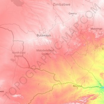
Name: Matabeleland South topographic map, elevation, terrain.
Location: Matabeleland South, Zimbabwe (-22.35634 26.70225 -19.48322 31.12130)
Average elevation: 959 m
Minimum elevation: 227 m
Maximum elevation: 1,597 m
Other topographic maps
Click on a map to view its topography, its elevation and its terrain.
Upper Ncema Dam
Upper Ncema Dam, Umzingwane, Matabeleland South, Zimbabwe
Average elevation: 1,154 m
Mzingwane
Mzingwane, Gwanda, Matabeleland South, Zimbabwe
Average elevation: 821 m
Limpopo River
Limpopo River, Beitbridge, Matabeleland South, Zimbabwe
Average elevation: 715 m
Matobo National Park
Matobo National Park, Matobo, Matabeleland South, Zimbabwe
Average elevation: 1,331 m
Mtshabezi Dam
Mtshabezi Dam, Gwanda, Matabeleland South, Zimbabwe
Average elevation: 1,051 m