
Valencian Community topographic map
Interactive map
Click on the map to display elevation.
About this map
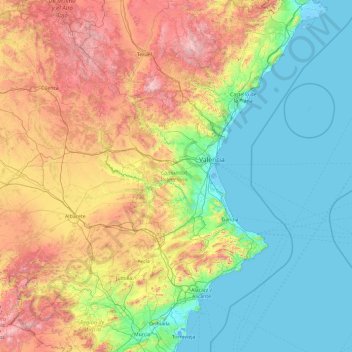
Name: Valencian Community topographic map, elevation, terrain.
Location: Valencian Community, Spain (37.84379 -1.52894 40.78863 0.69029)
Average elevation: 550 m
Minimum elevation: -5 m
Maximum elevation: 2,315 m
Other topographic maps
Click on a map to view its topography, its elevation and its terrain.
la Pobla de Farnals
la Pobla de Farnals, l'Horta Nord, Valencia, Valencian Community, Spain
Average elevation: 15 m
Aspe
Spain > Valencian Community > Aspe
Aspe, el Vinalopó Mitjà / El Vinalopó Medio, Alacant / Alicante, Valencian Community, 03680, Spain
Average elevation: 268 m