
Saxony topographic map
Interactive map
Click on the map to display elevation.
About this map
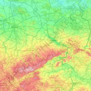
Name: Saxony topographic map, elevation, terrain.
Location: Saxony, Germany (50.17133 11.87225 51.68513 15.04181)
Average elevation: 290 m
Minimum elevation: 40 m
Maximum elevation: 1,235 m
Other topographic maps
Click on a map to view its topography, its elevation and its terrain.
Brand-Erbisdorf
Germany > Saxony > Brand-Erbisdorf
Brand-Erbisdorf, Mittelsachsen, Saxony, 09618, Germany
Average elevation: 490 m