
West Virginia topographic map
Interactive map
Click on the map to display elevation.
About this map
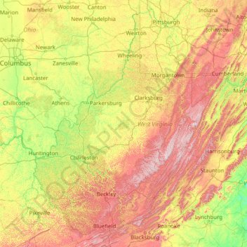
Name: West Virginia topographic map, elevation, terrain.
Location: West Virginia, USA (37.20148 -82.64474 40.63880 -77.71903)
Average elevation: 430 m
Minimum elevation: 84 m
Maximum elevation: 1,452 m
Other topographic maps
Click on a map to view its topography, its elevation and its terrain.
Blue Knob
Blue Knob, Greenbrier County, West Virginia, USA
Average elevation: 1,141 m