
Lahul and Spiti topographic map
Interactive map
Click on the map to display elevation.
About this map
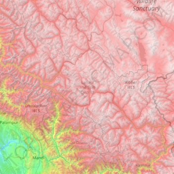
Name: Lahul and Spiti topographic map, elevation, terrain.
Location: Lahul and Spiti, Himachal Pradesh, India (31.75223 76.35852 33.25567 78.69266)
Average elevation: 4,276 m
Minimum elevation: 516 m
Maximum elevation: 6,611 m
Other topographic maps
Click on a map to view its topography, its elevation and its terrain.
Dobola
India > Himachal Pradesh > Dobola
Dobola, Chamba, Himachal Pradesh, 176314, India
Average elevation: 1,408 m
Panthaghatti
India > Himachal Pradesh > Panthaghatti
Panthaghatti, Solan, Himachal Pradesh, 171009, India
Average elevation: 1,746 m
Kullu
India > Himachal Pradesh > Kullu
Kullu, Himachal Pradesh, 175100, India
Average elevation: 1,808 m