
Brewster County topographic map
Interactive map
Click on the map to display elevation.
About this map
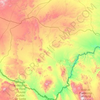
Name: Brewster County topographic map, elevation, terrain.
Location: Brewster County, Texas, USA (28.97153 -103.80075 30.66585 -102.32085)
Average elevation: 1,139 m
Minimum elevation: 464 m
Maximum elevation: 2,631 m
Other topographic maps
Click on a map to view its topography, its elevation and its terrain.
La Villita
USA > Texas > San Antonio
La Villita, San Antonio, Bexar County, Texas, USA
Average elevation: 202 m
Post Oak Ridge
USA > Texas > Lago Vista
Post Oak Ridge, Lago Vista, Travis County, Texas, 78645, USA
Average elevation: 314 m
Denny Mountain
Denny Mountain, Nacogdoches County, Texas, 75760, USA
Average elevation: 137 m
Guadalupe Peak
Guadalupe Peak, Culberson County, Texas, 79847, USA
Average elevation: 2,151 m
Big Bend National Park
USA > Texas > Panther Junction
Big Bend National Park, Main Park Road, Panther Junction, Brewster County, Texas, 79834, USA
Average elevation: 934 m