
Godavari topographic map
Interactive map
Click on the map to display elevation.
About this map
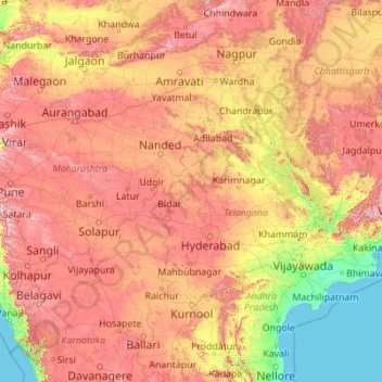
Name: Godavari topographic map, elevation, terrain.
Location: Godavari, Nizamabad, Telangana, 534452, India (16.68053 73.53222 20.05143 82.35356)
Average elevation: 380 m
Minimum elevation: -2 m
Maximum elevation: 1,440 m
Other topographic maps
Click on a map to view its topography, its elevation and its terrain.
Gandipet mandal
Gandipet mandal, Ranga Reddy District, Telangana, India
Average elevation: 559 m
Bhongir
India > Telangana > Bhongiri mandal
Bhongir, Bhongiri mandal, Yadadri Bhuvanagiri District, Telangana, 508100, India
Average elevation: 447 m
Ibrahim Bagh
India > Telangana > Gandipet mandal > Hyderabad
Ibrahim Bagh, Hyderabad, Gandipet mandal, Ranga Reddy District, Telangana, 500031, India
Average elevation: 527 m
Chengicherla
India > Telangana > Chengicherla
Chengicherla, Medipally mandal, Medchal–Malkajgiri, Telangana, 500092, India
Average elevation: 509 m
Ward 75 Red Hills
Ward 75 Red Hills, Greater Hyderabad Municipal Corporation Central Zone, Hyderabad, Telangana, India
Average elevation: 521 m