
Peru topographic map
Interactive map
Click on the map to display elevation.
About this map
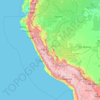
Name: Peru topographic map, elevation, terrain.
Location: Peru (-20.19845 -84.63565 -0.03928 -68.65199)
Average elevation: 645 m
Minimum elevation: -3 m
Maximum elevation: 6,020 m
The combination of tropical latitude, mountain ranges, topography variations, and two ocean currents (Humboldt and El Niño) gives Peru a large diversity of climates. The coastal region has moderate temperatures, low precipitation, and high humidity, except for its warmer, wetter northern reaches. In the mountain region, rain is frequent in summer, and temperature and humidity diminish with altitude up to the frozen peaks of the Andes. The Peruvian Amazon is characterized by heavy rainfall and high temperatures, except for its southernmost part, which has cold winters and seasonal rainfall.
Other topographic maps
Click on a map to view its topography, its elevation and its terrain.
Choquepata
Peru > Cusco > Vilcabamba
Choquepata, Vilcabamba, Province of La Convención, Cusco, Peru
Average elevation: 3,859 m
Limonchayoc
Limonchayoc, Ayna, Province of La Mar, Ayacucho, Peru
Average elevation: 1,045 m
Pacoyan
Peru > Pasco > Simón Bolívar
Pacoyan, Simón Bolívar, Province of Pasco, Pasco, Peru
Average elevation: 4,285 m
Huanchaco
Peru > La Libertad > Huanchaco
Huanchaco, Province of Trujillo, La Libertad, 045, Peru
Average elevation: 174 m
Chan Chan
Peru > La Libertad > Huanchaco
Chan Chan, Panamericana Norte, Huanchaco, Province of Trujillo, La Libertad, 13009, Peru
Average elevation: 27 m
Samaria
Peru > Loreto > Cahuapanas > Samaria
Samaria, Cahuapanas, Province of Datem del Marañón, Loreto, Peru
Average elevation: 209 m
Alpamayo
Peru > Ancash > Santa Cruz
Alpamayo, Santa Cruz, Huaylas, Ancash, Peru
Average elevation: 5,210 m
Chiclayo
Peru > Lambayeque > Chiclayo
Chiclayo, Province of Chiclayo, Lambayeque, Peru
Average elevation: 28 m
Pueblo Libre
Peru > Lima > Pueblo Libre
Pueblo Libre, Province of Lima, Lima, Peru
Average elevation: 83 m
Laguna Palococha
Laguna Palococha, AN-110, Ticapampa, Province of Recuay, Ancash, Peru
Average elevation: 3,765 m
Independencia
Peru > Lima > Independencia
Independencia, Province of Lima, Lima, Peru
Average elevation: 224 m
Villa El Salvador
Peru > Lima > Villa El Salvador
Villa El Salvador, Province of Lima, Lima, Peru
Average elevation: 104 m
Pueblo Libre
Peru > San Martín > Pueblo Libre
Pueblo Libre, Moyobamba, San Martín, Peru
Average elevation: 842 m
Machupicchu
Peru > Cusco > Machupicchu
Machupicchu, Province of Urubamba, Cusco, Peru
Average elevation: 3,640 m
Province of Pisco
Province of Pisco, Humay, Pisco, Ica, Peru
Average elevation: 587 m
San Juan de Miraflores
Peru > Apurímac > San Juan de Miraflores
San Juan de Miraflores, Andahuaylas, Apurímac, Peru
Average elevation: 3,428 m
Fundo La Esperanza
Peru > Ica > Fundo La Esperanza
Fundo La Esperanza, Pisco, Ica, Peru
Average elevation: 245 m
Province of Carhuaz
Province of Carhuaz, Marcará, Carhuaz, Ancash, Peru
Average elevation: 3,217 m
San Martín de Porres
Peru > Lima > San Martín de Porres
San Martín de Porres, Province of Lima, Lima, Peru
Average elevation: 55 m
Province of Recuay
Province of Recuay, Cátac, Recuay, Ancash, Peru
Average elevation: 4,232 m
Zona Reservada Cordillera Huayhuash
Zona Reservada Cordillera Huayhuash, cutambo pass and siula grande view point, Cajatambo, Lima, Peru
Average elevation: 4,319 m
Laguna Palococha
Laguna Palococha, AN-110, Ticapampa, Recuay, Ancash, Peru
Average elevation: 3,765 m
Province of Chiclayo
Peru > Lambayeque > Pucalá
Province of Chiclayo, Pucalá, Chiclayo, Lambayeque, Peru
Average elevation: 348 m
Province of San Marcos
Peru > Cajamarca > José Sabogal
Province of San Marcos, José Sabogal, San Marcos, Cajamarca, Peru
Average elevation: 3,865 m
San Vicente de Cañete
Peru > Lima > San Vicente de Cañete
San Vicente de Cañete, Cañete, Lima, Peru
Average elevation: 85 m