
Rio Grande topographic map
Interactive map
Click on the map to display elevation.
About this map
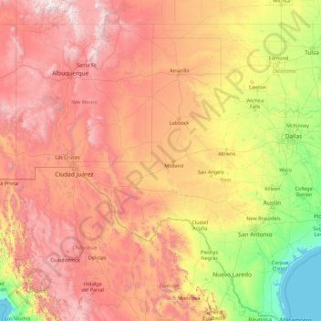
Name: Rio Grande topographic map, elevation, terrain.
Average elevation: 1,042 m
Minimum elevation: -1 m
Maximum elevation: 4,035 m
Other topographic maps
Click on a map to view its topography, its elevation and its terrain.
Coppell
United States of America > Texas > Coppell
Coppell, Dallas County, Texas, 75019, United States of America
Average elevation: 160 m