
Guam topographic map
Interactive map
Click on the map to display elevation.
Guam
A coral table reef surrounds most of Guam, and the limestone plateau provides the source for most of the island's fresh water. Steep coastal cliffs dominate the north, while mountains inform the topography of the island's southern end; lower hills typify the area in between.
About this map
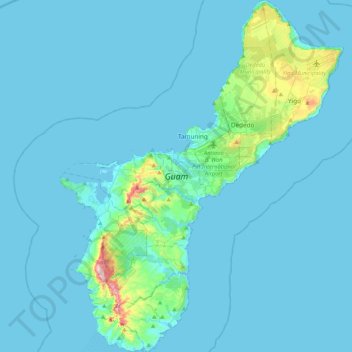
Name: Guam topographic map, elevation, terrain.
Location: Guam, Talo’fo’fo’ Municipality, Guam, United States (13.24599 144.61832 13.65438 144.95696)
Average elevation: 26 m
Minimum elevation: 0 m
Maximum elevation: 386 m