
Chu River topographic map
Interactive map
Click on the map to display elevation.
About this map
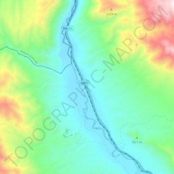
Name: Chu River topographic map, elevation, terrain.
Location: Chu River, Issyk-Kul Region, Kyrgyzstan (42.48687 75.81115 42.55905 75.86088)
Average elevation: 1,835 m
Minimum elevation: 1,499 m
Maximum elevation: 2,719 m
Other topographic maps
Click on a map to view its topography, its elevation and its terrain.
Кашка Суу
Кашка Суу, Issyk-Kul Region, Kyrgyzstan
Average elevation: 2,630 m
Токтогул
Токтогул, Issyk-Kul Region, Kyrgyzstan
Average elevation: 3,264 m
Ala-Kul Lake
Kyrgyzstan > Issyk-Kul Region > Karakol
Ala-Kul Lake, Karakol, Issyk-Kul Region, Kyrgyzstan
Average elevation: 3,701 m
North Engilchek Glacier
North Engilchek Glacier, Issyk-Kul Region, Kyrgyzstan
Average elevation: 4,153 m
Chon-Kyzyl-Suu
Chon-Kyzyl-Suu, Issyk-Kul Region, Kyrgyzstan
Average elevation: 2,583 m