
Iraqi Kurdistan topographic map
Interactive map
Click on the map to display elevation.
About this map
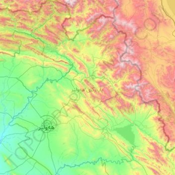
Name: Iraqi Kurdistan topographic map, elevation, terrain.
Location: Erbil, Iraqi Kurdistan, Iraq (35.42959 43.32230 37.32300 45.07187)
Average elevation: 886 m
Minimum elevation: 142 m
Maximum elevation: 3,628 m
Other topographic maps
Click on a map to view its topography, its elevation and its terrain.
Tasluja
Iraq > Iraqi Kurdistan > Tasluja
Tasluja, Sulaymaniyah, Iraqi Kurdistan, Iraq
Average elevation: 930 m
Rashkin
Iraq > Iraqi Kurdistan > Rashkin
Rashkin, Arbil District, Erbil, Iraqi Kurdistan, 440001, Iraq
Average elevation: 394 m