
Northern Province topographic map
Interactive map
Click on the map to display elevation.
About this map
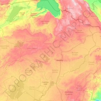
Name: Northern Province topographic map, elevation, terrain.
Location: Northern Province, Zambia (-11.52970 29.09965 -8.27128 32.39414)
Average elevation: 1,276 m
Minimum elevation: 628 m
Maximum elevation: 2,207 m
Other topographic maps
Click on a map to view its topography, its elevation and its terrain.
Mpulungu
Zambia > Northern Province > Mpulungu
Mpulungu, Mpulungu District, Northern Province, Zambia
Average elevation: 815 m
Mporokoso
Mporokoso, Mporokoso District, Northern Province, Zambia
Average elevation: 1,439 m