
Iraq topographic map
Interactive map
Click on the map to display elevation.
About this map
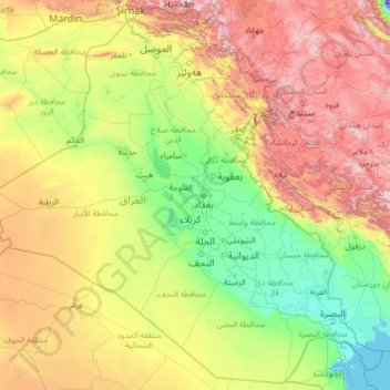
Name: Iraq topographic map, elevation, terrain.
Location: Iraq (29.05857 38.79264 37.38067 49.10677)
Average elevation: 633 m
Minimum elevation: -31 m
Maximum elevation: 3,640 m
The capital, Ninus or Nineveh, was taken by the Medes under Cyaxares, and some 200 years after Xenophon passed over its site, then mere mounds of earth. It remained buried until 1845, when Botta and Layard discovered the ruins of the Assyrian cities. The principal remains are those of Khorsabad, 16 km (10 mi) N.E. of Mosul; of Nimroud, supposed to be the ancient Calah; and of Kouyunjik, in all probability the ancient Nineveh. In these cities are found fragments of several great buildings which seem to have been palace-temples. They were constructed chiefly of sun-dried bricks, and all that remains of them is the lower part of the walls, decorated with sculpture and paintings, portions of the pavements, a few indications of the elevation, and some interesting works connected with the drainage.
Other topographic maps
Click on a map to view its topography, its elevation and its terrain.
South Mountain
Canada > Ontario > Stormont, Dundas and Glengarry Counties > North Dundas
South Mountain, North Dundas, Stormont, Dundas and Glengarry Counties, Eastern Ontario, Ontario, K0E 1W0, Canada
Average elevation: 82 m
Zimbabwe
Zimbabwe
Average elevation: 869 m
Baku
Azerbaijan > Absheron > Baku
Baku, Yasamal Raion, Baku City, Absheron, Azerbaijan
Average elevation: 30 m
Hubbard Glacier
United States > Alaska > Yakutat
Hubbard Glacier, Yakutat, Alaska, United States
Average elevation: 1,892 m
Newry
United States > Maine > Oxford County
Newry, Oxford County, Maine, 04261, United States
Average elevation: 392 m
Withersfield
United Kingdom > England > Suffolk > West Suffolk
Withersfield, West Suffolk, Suffolk, England, United Kingdom
Average elevation: 102 m
Évry
France > Bourgogne – Franche-Comté > Yonne
Évry, Sens, Yonne, Bourgogne – Franche-Comté, Metropolitan France, 89140, France
Average elevation: 68 m
Nerva
Spain > Andalusia > Cuenca Minera
Nerva, Cuenca Minera, Huelva, Andalusia, 21670, Spain
Average elevation: 365 m
Conway
United States > New Hampshire > Carroll County
Conway, Carroll County, New Hampshire, United States
Average elevation: 256 m
Hovingham
United Kingdom > England > North Yorkshire
Hovingham, North Yorkshire, England, YO62 4JU, United Kingdom
Average elevation: 51 m
Nunnington
United Kingdom > England > Herefordshire > Withington Marsh
Nunnington, Withington Marsh, Withington, Herefordshire, England, HR1 3NJ, United Kingdom
Average elevation: 63 m
Münchsmünster
Germany > Bavaria > Landkreis Pfaffenhofen an der Ilm
Münchsmünster, Landkreis Pfaffenhofen an der Ilm, Bavaria, 85126, Germany
Average elevation: 360 m
Mühleberg
Switzerland > Bern > Bern-Mittelland administrative district
Mühleberg, Bern-Mittelland administrative district, Bernese Mittelland administrative region, Bern, Switzerland
Average elevation: 551 m
New Orleans
United States > Louisiana > Orleans Parish
New Orleans, Orleans Parish, Louisiana, United States
Average elevation: 1 m
Bizana
South Africa > Eastern Cape > Alfred Nzo District Municipality > Mbizana Local Municipality
Bizana, Mbizana Local Municipality, Alfred Nzo District Municipality, Eastern Cape, South Africa
Average elevation: 823 m
Belvedere Marittimo
Belvedere Marittimo, Cosenza, Calabria, 87021, Italy
Average elevation: 266 m
Llanfyllin
United Kingdom > Wales > Powys
Llanfyllin, Powys, Wales, SY22 5AU, United Kingdom
Average elevation: 208 m
Serra de Santo António
Portugal > Santarém > Alcanena
Serra de Santo António, Alcanena, Santarém, Portugal
Average elevation: 338 m
Shurdington
United Kingdom > England > Gloucestershire > Tewkesbury
Shurdington, Tewkesbury, Gloucestershire, England, GL51 4TQ, United Kingdom
Average elevation: 87 m
Site of Community Importance Serra da Estrela
Site of Community Importance Serra da Estrela, Guarda, Portugal
Average elevation: 742 m
Amargadhi-06
Nepal > Sudurpashchim Province > Dadeldhura > Pokhara
Amargadhi-06, Pokhara, Amargadhi, Dadeldhura, Sudurpashchim Province, Nepal
Average elevation: 1,626 m
West St. Paul
United States > Minnesota > Dakota County
West St. Paul, Dakota County, Minnesota, 55118, United States
Average elevation: 294 m
Wollaton
United Kingdom > England > Nottingham
Wollaton, Nottingham, England, NG8 2AF, United Kingdom
Average elevation: 58 m
Bramcote
United Kingdom > England > Warwickshire > Rugby
Bramcote, Rugby, Warwickshire, England, CV11 6QX, United Kingdom
Average elevation: 105 m
Menifee County
Menifee County, Kentucky, United States
Average elevation: 313 m
Kurgan
Russia > Kurgan Oblast > Kurgan
Kurgan, Kurgan Oblast, Ural Federal District, Russia
Average elevation: 96 m
Battle
United Kingdom > England > East Sussex > Rother > Battle
Battle, Rother, East Sussex, England, United Kingdom
Average elevation: 66 m
Ninfield
United Kingdom > England > East Sussex > Wealden > Ninfield
Ninfield, Wealden, East Sussex, England, United Kingdom
Average elevation: 37 m
Hastings
United Kingdom > England > East Sussex
Hastings, East Sussex, England, United Kingdom
Average elevation: 36 m
Hawkhurst
United Kingdom > England > Kent > Tunbridge Wells
Hawkhurst, Tunbridge Wells, Kent, England, United Kingdom
Average elevation: 67 m
Zamboanga del Norte
Zamboanga del Norte, Zamboanga Peninsula, Philippines
Average elevation: 78 m
Searsmont
United States > Maine > Waldo County
Searsmont, Waldo County, Maine, United States
Average elevation: 98 m
Lytham St Annes
United Kingdom > England > Lancashire > Borough of Fylde
Lytham St Annes, Borough of Fylde, Lancashire, England, FY8 4AR, United Kingdom
Average elevation: 5 m
Choquepata
Peru > Cusco > Vilcabamba
Choquepata, Vilcabamba, Province of La Convención, Cusco, Peru
Average elevation: 3,859 m
Swannington
United Kingdom > England > Norfolk > Broadland
Swannington, Broadland, Norfolk, England, United Kingdom
Average elevation: 29 m
Fulbeck
United Kingdom > England > Lincolnshire > South Kesteven
Fulbeck, South Kesteven, Lincolnshire, England, NG32 3JJ, United Kingdom
Average elevation: 61 m
Manukan
Philippines > Zamboanga del Norte
Manukan, Zamboanga del Norte, Zamboanga Peninsula, 7110, Philippines
Average elevation: 59 m
Shippensburg
United States > Pennsylvania > Cumberland County
Shippensburg, Cumberland County, Pennsylvania, 17257, United States
Average elevation: 213 m
Satolas-et-Bonce
France > Auvergne-Rhône-Alpes > Isère
Satolas-et-Bonce, La Tour-du-Pin, Isère, Auvergne-Rhône-Alpes, Metropolitan France, 38290, France
Average elevation: 235 m
Fort McPherson
Canada > Northwest Territories
Fort McPherson, Gwich'in Settlement Area, Northwest Territories, X0E 0J0, Canada
Average elevation: 27 m
Pambujan
Pambujan, Northern Samar, Eastern Visayas, 6413, Philippines
Average elevation: 2 m
Holden
United States > Massachusetts > Worcester County
Holden, Worcester County, Massachusetts, United States
Average elevation: 248 m
Auburn
United States > Massachusetts > Worcester County
Auburn, Worcester County, Massachusetts, United States
Average elevation: 187 m
Hamlin
United States > Texas > Jones County
Hamlin, Jones County, Texas, 79520, United States
Average elevation: 526 m