Geolocate

Lozère topographic map

Interactive map

Click on the map to display elevation.

About this map

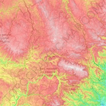
Name: Lozère topographic map, elevation, terrain.

Location: Lozère, Occitania, Metropolitan France, France (44.10934 2.98226 44.97578 3.99836)

Average elevation: 958 m

Minimum elevation: 122 m

Maximum elevation: 1,697 m

Other topographic maps

Click on a map to view its topography, its elevation and its terrain.

Pyrenees

France > Occitania >

In the Western Pyrenees, from the Basque mountains near the Bay of Biscay of the Atlantic Ocean, the average elevation gradually increases from west to east.

Average elevation: 2,716 m

Bay

France > Occitania > Gard > Canaules-et-Argentières

Average elevation: 98 m

Cominac

France > Occitania > Ariège > Ercé

Average elevation: 784 m

Les Cloutets

France > Occitania > Ariège > Soulan

Average elevation: 852 m

Camp Bernard

France > Occitania > Gard > Val-d'Aigoual > Fenouillet

Average elevation: 636 m

Balarin

France > Occitania > Gers > Montréal

Average elevation: 128 m

Pré d'en Mathieu

France > Occitania > Ariège > Mijanès

Average elevation: 1,788 m

Mont Valier

France > Occitania > Ariège > Seix

On August 18, 2023, French general Jean-Louis Georgelin fell to his death while hiking on Mont Valier, at an altitude of 2,650 metres (8,690 ft).

Average elevation: 2,217 m

Les Tour

France > Occitania > Aveyron > Druelle Balsac > Druelle

Average elevation: 582 m

Lahore

France > Occitania > Hautes Pyrenees > Viger > Buala

Average elevation: 569 m

Boirargues

France > Occitania > Hérault > Lattes

Average elevation: 14 m

Cominac

France > Occitania > Ariège > Ercé

Average elevation: 784 m

Pic de Finestrelles

France > Occitania > Pyrénées-Orientales > Eyne

Pic de Finestrelles is a mountain located in the Oriental Pyrenees, on the border of France and Spain. It has an altitude of 2,826 metres (9,272 ft) above sea level.

Average elevation: 2,502 m

Lac d'Estom

France > Occitania > Hautes Pyrenees > Cauterets

Average elevation: 2,194 m

Pech Cardou

France > Occitania > Aude > Serres

Average elevation: 427 m

Carol

France > Occitania > Hérault > Octon

Average elevation: 271 m

Laquet de la Cabarère

France > Occitania > Ariège > Ustou

Average elevation: 2,024 m

Roc du Caroux

France > Occitania > Hérault > Rosis

Average elevation: 731 m

Réals

France > Occitania > Hérault > Cessenon-sur-Orb

Average elevation: 89 m

Seilhols

France > Occitania > Hérault > Colombières-sur-Orb

Average elevation: 434 m

Vignemale

France > Occitania > Hautes Pyrenees > Cauterets

Average elevation: 2,691 m

Pic de Nore

France > Occitania > Aude > Pradelles-Cabardès

Average elevation: 1,063 m

Belot

France > Occitania > Hérault > La Salvetat-sur-Agout

Average elevation: 753 m

Issis

France > Occitania > Aveyron > Creissels

Average elevation: 540 m

La Mothe

France > Occitania > Tarn > Castelnau-de-Lévis

Average elevation: 203 m

Colline de Chabanette

France > Occitania > Hérault > Sète

Average elevation: 28 m

Tarassac

France > Occitania > Hérault > Mons

Average elevation: 281 m

Lac de Gaube

France > Occitania > Hautes Pyrenees > Cauterets

The lake is situated in an altitude of 1725 m, an egg-shaped form stretching itself along a north–south axis in the valley of Gaube. This steep-sided valley is located at the foot of the Vignemale (3298M). The lake is surrounded by the peak Mayouret (2688 m) to the east, the big Peak of the Paloumères (2720…

Average elevation: 2,079 m

Cantobre

France > Occitania > Aveyron > Nant

Average elevation: 666 m

Riols

France > Occitania > Hérault > Graissessac

Average elevation: 499 m

Mont Béas

France > Occitania > Ariège > Le Port

Average elevation: 1,394 m

Payolle

France > Occitania > Hautes Pyrenees > Campan

Average elevation: 1,281 m

La Quille

France > Occitania > Hérault > Les Plans

Average elevation: 643 m

Martinat

France > Occitania > Ariège > Montferrier

Average elevation: 967 m

Thonas

France > Occitania > Lozère > Saint-Germain-de-Calberte

Average elevation: 463 m

Saint-Esprit

France > Occitania > Lot > Martel

Average elevation: 239 m

La Malette

France > Occitania > Aveyron > Entraygues-sur-Truyère

Average elevation: 410 m

Brugales

France > Occitania > Lot > Laval-de-Cère

Average elevation: 311 m

Pointe ronde

France > Occitania > Ariège > Ustou

Average elevation: 1,814 m

Montpellier

France > Occitania > Hérault > Montpellier

Average elevation: 72 m

Lavail

France > Occitania > Ariège > Ascou

Average elevation: 1,356 m

Toulouse

France > Occitania > Haute-Garonne > Toulouse

The first half of the 14th century was a prosperous period, despite the dismemberment in 1317 of the very large bishopric of Toulouse (which lost two thirds of its area and a large part of its income, a loss only partially compensated by its elevation to the rank of archbishopric), and the episode of the…

Average elevation: 173 m

Le Fageas

France > Occitania > Gard > L'Estréchure

Average elevation: 854 m

Espinassous

France > Occitania > Gard > Lanuéjols > Espinassous

Average elevation: 866 m

Château de Salleneuve

France > Occitania > Gers > Mont-d'Astarac

Average elevation: 286 m

Massal

France > Occitania > Tarn-et-Garonne > Caussade > Massal

Average elevation: 137 m

Salau

France > Occitania > Ariège > Couflens > Salau

Average elevation: 1,327 m

Casteil

France > Occitania > Pyrénées-Orientales > Casteil > Casteil

Average elevation: 1,038 m

Las Planes

France > Occitania > Tarn > Senouillac > Las Planes

Average elevation: 192 m

La Graufesenque

France > Occitania > Aveyron > Millau > La Graufesenque

Average elevation: 529 m

Conne

France > Occitania > Haute-Garonne > Mane

Average elevation: 329 m

Lac d'en Brunet

France > Occitania > Belleserre

Average elevation: 233 m

Vallée du Marcadau

France > Occitania > Hautes Pyrenees > Cauterets

Average elevation: 1,993 m

Sidobre

France > Occitania > Tarn > Graulhet > Sidobre

Average elevation: 219 m

Issis

France > Occitania > Aveyron > Creissels

Average elevation: 540 m

Llo

France > Occitania > Pyrénées-Orientales > Llo > Llo

Average elevation: 1,562 m

Concots

France > Occitania > Lot > Concots > Concots

Average elevation: 268 m

Campan

France > Occitania > Hautes Pyrenees > Campan > Campan

Average elevation: 880 m

Florac

France > Occitania > Florac Trois Rivières > Florac

Average elevation: 828 m

Au Pouy

France > Occitania > Au Pouy

Average elevation: 161 m

Col de Peyresourde

France > Occitania > Loudervielle

Average elevation: 1,615 m

Privat

France > Occitania > Privat

Average elevation: 135 m

A la Garenne

France > Occitania > A la Garenne

Average elevation: 215 m

Les Avens

France > Occitania > La Cadière-et-Cambo

Average elevation: 492 m

La Barraque Basse

France > Occitania > Coufouleux

Average elevation: 147 m

Las Closes

France > Occitania > Pyrénées-Orientales > Prades

Average elevation: 444 m

La Beloterie

France > Occitania > La Beloterie

Average elevation: 565 m

Puech-Mege

France > Occitania > Puéchabon

Average elevation: 222 m

Bouysset

France > Occitania > Bouysset

Average elevation: 229 m

Redoules

France > Occitania > Redoules

Average elevation: 304 m

Larroque

France > Occitania > Larroque

Average elevation: 252 m

Le Pest

France > Occitania > Sainte-Anne

Average elevation: 162 m

A Liage

France > Occitania > A Liage

Average elevation: 133 m

Cape

France > Occitania > Gers > L'Isle-de-Noé > Cape

Average elevation: 174 m

Roquebrune

France > Occitania > Roquebrune

Average elevation: 436 m

Baqué

France > Occitania > Baqué

Average elevation: 157 m

Éas

France > Occitania > Arrens-Marsous

Average elevation: 1,003 m

Conques

France > Occitania > Conques

Average elevation: 429 m

Ys

France > Occitania > Hautes Pyrenees > Bareilles

Average elevation: 1,118 m

Eget Village

France > Occitania > Hautes Pyrenees > Aragnouet > Eget Village

Average elevation: 1,560 m