
Nias topographic map
Interactive map
Click on the map to display elevation.
About this map
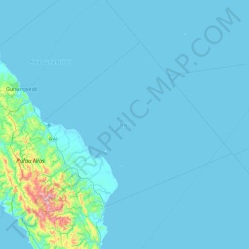
Name: Nias topographic map, elevation, terrain.
Location: Nias, North Sumatra, Indonesia (0.88374 97.48352 1.45130 98.33944)
Average elevation: 39 m
Minimum elevation: 0 m
Maximum elevation: 838 m
Other topographic maps
Click on a map to view its topography, its elevation and its terrain.
Tebing Tinggi
Indonesia > North Sumatra > Tebing Tinggi
Tebing Tinggi, Kota Tebing Tinggi–Serdang Bedagai, North Sumatra, 20600, Indonesia
Average elevation: 34 m